













































































AI Landscape Design From Your Yard Photo
Sign In

AI Landscape Design From Your Yard Photo

Upload a real outdoor photo, choose a landscape direction, and edit the prompt before creating a concept that keeps the site and camera as visual anchors.

Start with a visual direction, then edit the brief for your real outdoor space.

Upload an Authorized Yard or Garden Photo*
Try a Fictional Backyard Sample

0 / 800

Copy Protection
Credits required:28 credits
Public VisibilityAllow this result to appear in public inspiration surfaces.

Your Landscape Concept

Image

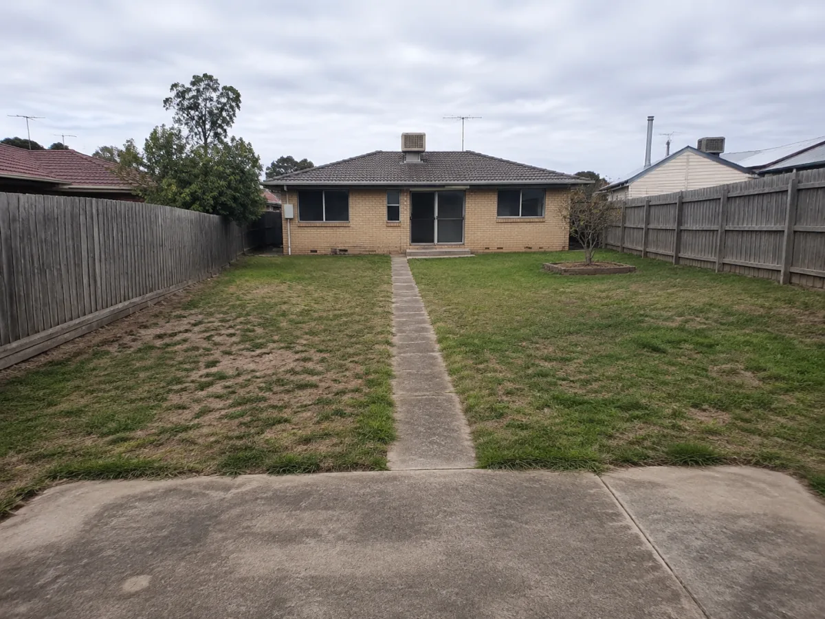
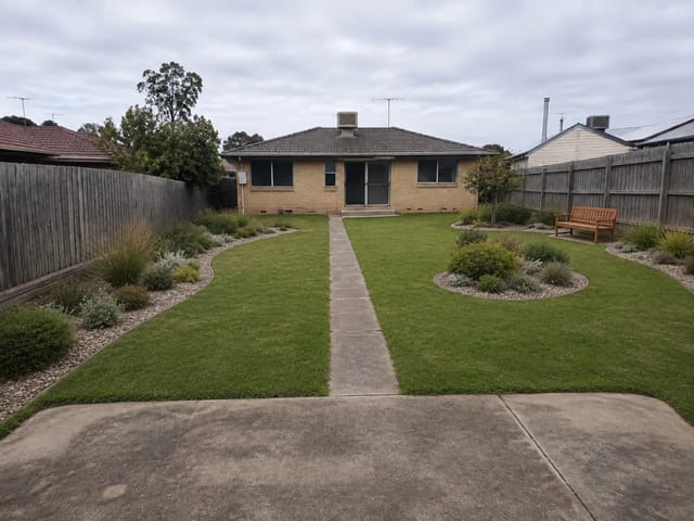
Unlandscaped fictional suburban backyard before AI landscape design
Original Yard
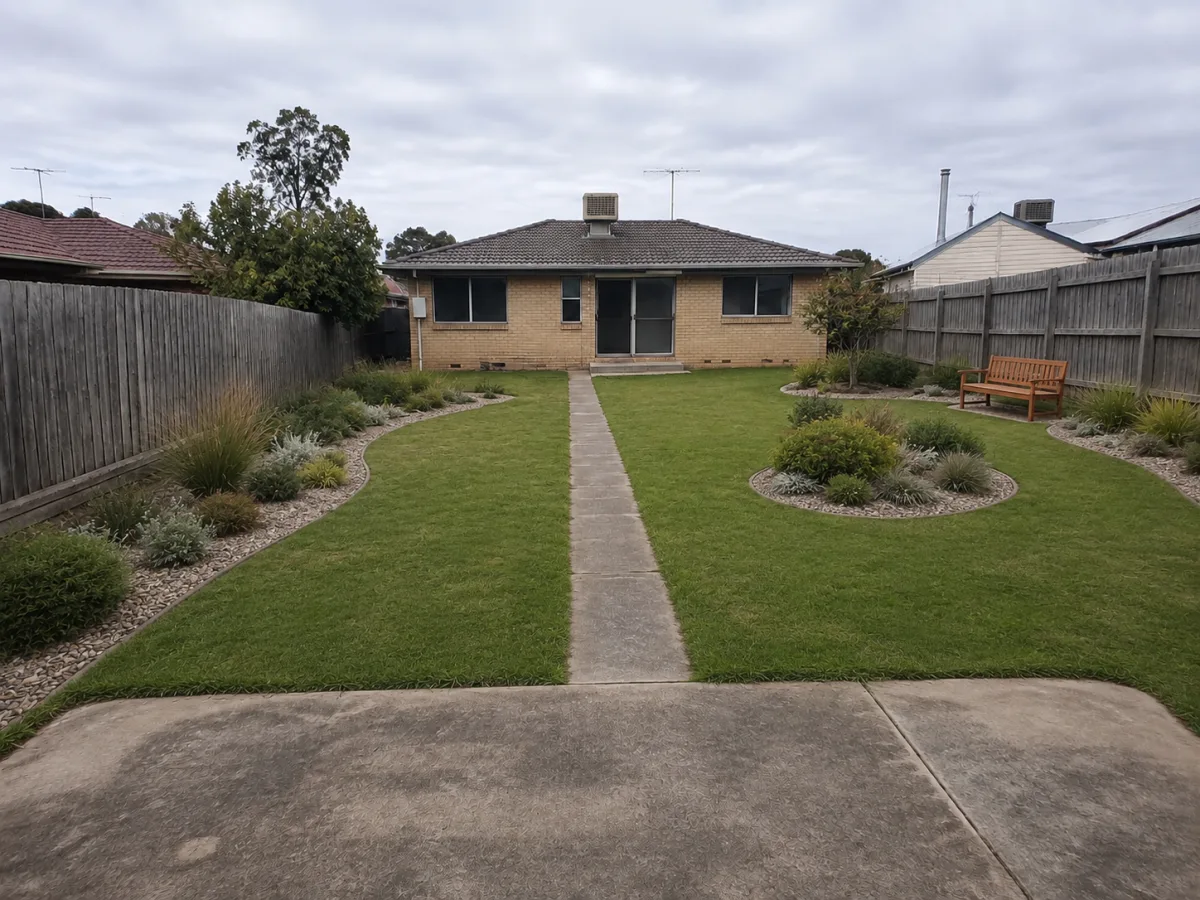
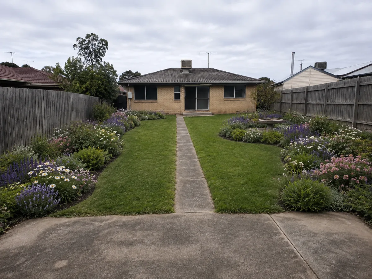
Modern low-maintenance landscape concept preserving the original house, fences, path, and camera
Modern Concept

Visualize a Garden Direction on the Outdoor Space You Already Have

A useful AI landscape design starts with the real yard rather than an imaginary plan. NanoPic uses your uploaded photo as the visual reference and asks the model to hold the visible house, boundary fences, gates, existing paths, grade, mature trees, neighboring context, camera position, and lens perspective steady. The selected style and your editable notes then guide changes to lawn, planting beds, groundcover, edging, gravel, movable seating, and other concept-level landscape elements. This creates an image for comparing atmosphere, composition, and priorities before anyone measures the site. It is not a survey, planting specification, drainage analysis, cost estimate, construction drawing, or contractor-ready plan. Generative models can still shift geometry, misread scale, or invent details, so every output should be checked against the original photo and verified by qualified local professionals before a real project begins.

Three Landscape Directions, One Unchanged Yard View

Each example begins with the same fictional backyard. The house, fence lines, straight central path, terrain, trees, and eye-level camera remain the comparison anchors, while the planting language changes. These are original NanoPic demonstration assets, not copied competitor images and not evidence of a completed installation.

Modern low-maintenance AI landscape design for the fictional sample yard

Modern Low-Maintenance Yard

Layered grasses, restrained shrubs, repaired lawn, gravel mulch, and a modest seating area create a calmer contemporary direction. The concept intentionally avoids moving the path, changing the house, or adding a large permanent amenity. Use this kind of preview to decide whether you prefer stronger bed structure, more open lawn, or a quieter material palette—not to infer exact bed depths, quantities, drainage, or installation cost.

Use This Look
How to Use AI Landscape Design Without Losing the Real Site

The quality of the reference photo and the restraint of the brief matter more than decorative adjectives. Work in three reviewable steps and keep the source visible beside every result.

1. Photograph the Whole Decision Area

Use a clear, level photo taken from the viewpoint you expect to discuss later. Include the house edge or another fixed reference, complete fence or wall lines, gates, existing paths, changes in grade, important trees, and enough foreground to understand access. Avoid extreme wide-angle lenses, screenshots, heavy filters, night images, and photos where vehicles or foliage hide most boundaries. Upload only an image you own or are authorized to edit. The source photo is not a measured base plan, but visible anchors make structural drift easier to spot.

Clear fictional backyard source photo with visible house, fences, path, terrain, and camera perspective

2. Choose a Direction, Then Edit the Notes

Select Modern Low-Maintenance, Cottage Pollinator, or Japanese-Inspired as a starting vocabulary. The prompt remains editable so you can name the zone, the feeling, and a few priorities: keep open lawn, soften one fence, add a compact seating area, preserve a tree, or reduce visual clutter. State what must remain unchanged before listing additions. A focused brief gives the model fewer reasons to invent architecture, move boundaries, or fill every empty area with oversized planting.

Landscape style direction applied to the same fictional backyard while preserving fixed site features

3. Compare the Output With the Original

Check the house footprint, openings, fence posts, gate locations, path width and alignment, visible slope, tree positions, camera horizon, and neighboring context before judging the style. Then examine plant scale, sight lines, walking clearance, door access, and whether new features appear to float or block drainage routes. Save promising concepts as visual references, not specifications. A landscaper, landscape architect, horticulturist, engineer, utility locator, or local authority may need to confirm conditions the photo cannot reveal.

Cottage garden result ready for visual comparison against the unchanged original yard photo

What This Landscape Visualizer Is Designed to Preserve and Change

The generator separates fixed visual anchors from editable concept layers. That distinction helps keep the result relevant to the photographed property while remaining honest about image-generation limits.

House and Boundary Anchors

The prompt protects the visible house, roofline, windows, doors, decks, fixed walls, fences, gates, and property boundaries. This makes the output easier to compare with the source. It does not prove legal boundaries, setbacks, easements, ownership, structural condition, or permit compliance, and the model may still introduce drift that you must reject.

Path, Grade, and Camera Continuity

Existing path alignment, terrain, grading cues, camera position, lens perspective, framing, and daylight direction are written into every request. Keeping these visual constants supports before-and-after review. A single photo cannot reveal level measurements, subsurface conditions, drainage performance, accessibility slopes, or utilities, so never treat apparent geometry as measured fact.

Editable Planting Character

Change bed rhythm, perceived density, color balance, groundcover, lawn condition, shrub massing, and broad planting character. The model creates plausible-looking vegetation, but it does not reliably identify exact species or confirm hardiness, invasiveness, mature size, toxicity, water demand, shade tolerance, allergy risk, wildlife value, or local availability.

Concept-Level Outdoor Elements

Prompts may explore small seating zones, movable furniture, restrained gravel, edging, mulch, stepping accents, or other light landscape elements. Any real patio, retaining structure, pool, fire feature, electrical work, irrigation, lighting, or excavation requires measurements, engineering where applicable, product specifications, code review, and safe utility checks.

Multiple Visual Directions

Run separate styles on the same source so the decision remains about design direction rather than a different property. Comparing three restrained concepts often reveals whether you value openness, seasonal color, visual order, privacy, or lower perceived maintenance. Model variation means results will not be deterministic, even when you reuse the same photo and notes.

Original-and-Concept Comparison

The preview keeps the uploaded photo beside the generated concept so you can compare boundaries, access, terrain, building geometry, camera position, and landscape scale. Use the pair to reject drift before discussing the visual direction with anyone else; a polished result should never replace the untouched source image.

Review the AI Landscape Concept Before You Share It

A photorealistic result can feel authoritative even when it is wrong. Use a disciplined visual check and keep the limitations attached to the image.

Perspective and Building Check

Place source and output side by side. Compare roof edges, doors, windows, wall lengths, fence convergence, horizon, and camera height. Reject results that enlarge the yard, move the house, invent openings, straighten a real slope, or subtly shift the viewpoint. A more attractive composition is not useful if it represents a different property.

Boundary and Route Check

Trace every fence line, gate, path, step, driveway edge, and visible grade break. Confirm that walking routes and access points remain open. The model does not know the legal boundary, easement, emergency route, utility corridor, or maintenance access, so even a visually preserved line needs real-world verification.

Plant Scale Check

Compare proposed planting with windows, fence panels, doors, and people-free architectural references in the scene. Look for shrubs that would outgrow openings, implausible bloom density, repeated plant textures, floating trunks, or vegetation that hides hazards. Do not infer exact mature size or suitability from a generated appearance.

Materials and Drainage Check

Inspect gravel, edging, paving, soil, steps, and seating contact shadows. Watch for surfaces that appear to cover drains, air vents, thresholds, roots, or grade transitions. The generator cannot see underground utilities, foundation drainage, runoff patterns, soil structure, or waterproofing, so material placement remains illustrative.

Label and Source Check

Keep the original photo with the generated concept and label the output clearly as AI-generated visualization. Do not present it as completed work, an approved design, a landscape architect's drawing, a nursery recommendation, or a contractor commitment. If the property is not yours, confirm authorization before uploading or sharing a modified view.

Professional Handoff Check

When a direction survives visual review, document what you actually like: open lawn, layered edge planting, a quiet gravel palette, more seasonal color, or a compact social zone. Give that preference—not invented measurements—to the professional who will assess dimensions, climate, soil, sun, water, drainage, safety, codes, budget, and construction.

AI Landscape Design FAQ

Answers about real-yard photos, preservation, styles, plants, dimensions, cost, professional use, and the difference from exterior design.

What kind of photo works best for AI landscape design?

Use a clear, level image with the whole decision area visible. Include fixed references such as the house edge, fences, gates, paths, steps, mature trees, and visible changes in grade. Soft daylight and a normal phone lens are easier to interpret than night scenes, panoramas, extreme wide-angle views, screenshots, or heavily filtered photos. Upload only a photo you own or are authorized to edit.

Will NanoPic keep my house, fence, path, and camera exactly the same?

The template strongly instructs the model to preserve those visible anchors, and the example review is built around them. Generative AI can still move an opening, bend a fence, widen a path, flatten terrain, or shift perspective. Always compare the output with the original and reject drift. “Preserve” is a prompt constraint, not a survey-grade guarantee.

Can this AI garden design choose plants that will thrive where I live?

No reliable suitability claim is made. The output can communicate visual roles such as low flowering edge, medium evergreen mass, airy ornamental texture, or seasonal color. It does not assess hardiness zone, local climate, soil, drainage, sun hours, water restrictions, invasiveness, toxicity, allergies, mature size, wildlife value, or nursery supply. Ask a qualified local plant professional to translate the visual direction into species.

Does the result include accurate measurements or a scaled landscape plan?

No. A single perspective photo is not a measured survey, and this generator does not return dimensions, scale bars, CAD, planting plans, grading plans, irrigation drawings, lighting plans, details, or quantities. Apparent spacing can be visually persuasive while physically wrong. Measure the site separately and use appropriate design documentation before purchasing or construction.

Can AI Landscape Design estimate the cost of the yard shown?

No. The page does not calculate labor, demolition, access, excavation, drainage, soil preparation, irrigation, plants, materials, equipment, waste, permits, taxes, regional pricing, maintenance, or contingency. Use the concept to describe a preferred direction, then request site-specific scope and pricing from qualified providers. Do not treat visible materials or plant counts as a bill of quantities.

Is this a contractor-ready landscape design?

No. It is concept visualization only. It cannot verify boundaries, utilities, structure, drainage, accessibility, fire safety, local codes, permits, product installation, plant suitability, or construction feasibility. A professional may use a labeled AI image to understand your taste, but the image must not be presented as a construction plan, approved drawing, specification, or commitment from a contractor.

Which landscape styles can I try?

The page starts with Modern Low-Maintenance, Cottage Pollinator, and Japanese-Inspired directions. Each is a broad visual vocabulary rather than a fixed catalog design. You can edit the notes to keep lawn, protect a tree, soften one boundary, reduce planting density, change color emphasis, or define a small seating zone while retaining the source photo's fixed anchors.

How is AI Landscape Design different from AI Exterior Design?

AI Landscape Design is site-facing: planting, lawn, groundcover, bed rhythm, restrained hardscape, and removable outdoor elements around an existing property. AI Exterior Design is building-facing: facade colors, cladding, trim, entry accents, and exterior lighting. Both protect geometry and camera, but separating the tasks prevents a landscape prompt from accidentally repainting or rebuilding the house.

Should I upload a neighbor's yard or a property I do not own?

Upload only a photo you own or are authorized to edit. A yard image can reveal a home, neighboring property, access routes, or other private context, so crop unrelated areas when practical and avoid sharing a generated concept as if the owner approved it. Keep the untouched source and label the result as an AI-generated visualization.

Can I explore the page without starting a generation?

Yes. You can open the page, load the fictional sample, compare the three directions, and edit the landscape notes without submitting a task. Starting a generation requires sign-in. This makes it possible to prepare and review the brief first, while keeping the original photo visible for later comparison.

Create a Landscape Concept From Your Real Outdoor Photo

Keep the property anchors visible, choose one design direction, edit the notes, and review the result beside the source before taking the idea to a qualified local professional.